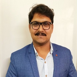
Vikrant Nikam
Director & CEO
Geo-spatial Hydrological Modeling Expert
M.Tech (RS & GIS)
Director & CEO
Geo-spatial Hydrological Modeling Expert
M.Tech (RS & GIS)
He is the one who strongly believed in the vision of spreading and penetrating the awareness of GIS at the bottom of society through education research institute. He is very passionate about teaching especially when it comes to geo-information science. Meet our CEO who is very positive and optimistic with loads of humility.
He has pursued his B.Tech in Agricultural Engineering from KKWCAET, MPKV, Rahuri, and during this tenure, he got fascinated by the geospatial technology and then the journey started with the M.Tech in RS & GIS applications in Water Resources from IIRS(ISRO), Dehradun.
His area of interest is Remote Sensing Data Assimilation, Macroscale Hydrological Modeling, Urban Utilities Management, and Geospatial Survey.
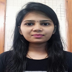
LULC Modelling Expert
MS Geo-Information and Earth Observation
Chief Technology Officer
LULC Modelling Expert
MS Geo-Information and Earth Observation
Meet our Chief Technology Officer whose area of interest is remote sensing, landscape & conservation ecology, agriculture, and LULC. She is a very enthusiastic researcher in the field of remote sensing for natural resource management to intervene at the policy level. She has played an important role in different projects where RS and GIS had a crucial role in agricultural risk assessment, crop type, and its health mapping & monitoring, mapping of vegetation types at the regional scale in Africa and India, mapping of ecosystem services, etc.
She has pursued B.Tech in agriculture IT from AAU, Gujrat, and MS in Geo-information Science and Earth Observation for Natural Resources Management from one of the world's prestigious institute ITC, UT, Netherlands.
She has a strong vision regarding the potential of RS and GIS technology to derive the solutions from a local scale to the global. Apart from research, she is a fun-loving personality and she is very compassionate and bold regarding her beliefs. She is a good communicator and she loves teaching.
Geospatial Data Handling Expert
M.Tech (Town & Country Planning), BE (Civil Engg.)
GIS Training Executive
Geospatial Data Handling Expert
M.Tech (Town & Country Planning), BE (Civil Engg.)
Meet our GIS trainer; she is very humble and always smiling. She is very enthusiastic about the applications of open-source Remote Sensing and GIS platforms in natural resource management and town planning.
She has pursued a B.E. in Civil Engineering from J.I.T. Nashik. She has masters in Town and Country Planning from Sandip University, Nashik. During her M.Tech. thesis she has performed various GIS tools and analysis. She has 2 years industrial experience as Junior Planner at KPMG, Nashik.
She has conspicuous skills in GIS software viz. QGIS, ArcGIS, along with Auto-CAD, Revit Architecture.

Research Scholar IIT Bombay
Numerical Weather Prediction Expert
Field of Interest:
Numerical weather prediction, Extreme precipitation forecast, Local Climate Zones, Land surface feedback, Remote sensing, Geographic Information System
TECHNICAL SKILLS/ Software Expertise:
• Languages: Python, R, NCL
• Models: Weather Research & Forecasting (WRF) Model, HEC-HMS, HEC-RAS, MIKE11
• Softwares: ArcGIS, QGIS, ERDAS, SAGA-GIS
• Extra: High-Performance Computing, Bash, LATEX, MS Office
Qualifications:
Doctor of Philosophy (IIT Bombay),
Master of Technology: Remote Sensing & GIS (Water Resources),
Bachelor of Technology: Agricultural Engineering
Research Scholar IIT Roorkee
Time Series Analysis Expert
Field of Interest:
Characterization of Droughts, Time Series Analysis, Soil Erosion and Sediment Yield Modelling
Qualifications:
Research Scholar, Department of Water Resources Development and Management, Indian Institute of Technology Roorkee
Masters of Science (Research): Climate Studies - IIT Bombay
M.Tech: Water resources Development and Irrigation Engg.- NIT Raipur
B. Tech - Civil Engg. Parala Maharaja Engineering College (PMEC), Berhampur

M.Tech (RS & GIS), IIRS
Geo-spatial Business Analyst
Field of Interest:
Remote Sensing and Geographic Information System
TECHNICAL SKILLS/ Software Expertise:
• Languages: Python, SQL, HTML, JS, CSS
• Models: HEC-HMS, HEC-RAS
• Softwares: ArcGIS, QGIS, ERDAS
Professional Experience:
5 years in GIS/IT industry as a GIS analyst with emphasis in designing solution for Geo-enabling non-GIS/MIS data.
Qualifications:
Master of Technology: Remote Sensing & GIS (Water Resources),
Bachelor of Technology: ECE (Birla Institute of Applied Sciences)

B.Tech. (Agril. Engg.)
GIS Data Analysis
Meet our GIS Data Analyst. She is very enthusiastic about the applications of open-source remote sensing and GIS platforms in natural resources management.
She has pursued B. Tech (Agril. Engg.) from Dr.BSKKV, Dapoli, and she has completed her four-month in-plant internship at the Albedo Foundation and later joined us to educate people in GIS.
She has outstanding skills in GIS software viz. QGIS, JOSM, ArcGIS, GRAM++, and SAGA
Research Associate, NAHEP-CAAST
Hydrological Modeling Expert
Field of Interest:
Impacts of Climate Change on Agriculture, Environmental Impact Assessment (EIA), Hydrological Modeling, Remote Sensing and Geographic Information System
TECHNICAL SKILLS/ Software Expertise:
Models: HEC-HMS, GMDH (Data Mining), HEC-RAS, RUSLE, SDSM
Software: ArcGIS, ERDAS, MatLab, SDSM, GMDH Shell
Changepoint analyzer, SPSS, Excelstat
Qualifications:
Doctor of Philosophy: Water Resources Engineering (NIT, Surat),
Master of Technology: Water Resources Engineering (NIT, Surat),
Bachelor of Technology: Agricultural Engineering (MPKV, Rahuri)
Developed by Collabx