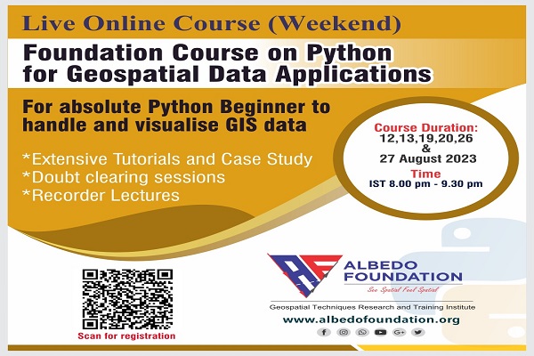
If you are new to the programming world, join this course and boost your programming confidence by 60% with Python.
This is a weekend course, so you don't have to worry about your daily schedule or work frame. Our course instructor will teach you the Python basics needed for the GIS and programming related to GIS data handling and visualization on weekends (2 weekends). She will provide the assignments regarding the taught concepts for your practice. If you have doubts regarding the assignments, don't worry; we have arranged a counselling lecture for you every Wednesday(Evening/Night session).
For geospatial data handling with Python demo results, click here
This course will total 30 hours (12 hours of coursework + 18 hours of hands-on assignments). The coursework session will be on weekends from IST 8.00 pm to 9.30 pm, and the counselling lecture will be on Wednesday (flexible according to the majority of participants' choices)
Know our Course Instructor
Our passionate and visionary course instructor designed whole course, who has pursued her MS in Geo-information Science from ITC, UT. She has pursued her B.Tech in Agricultural IT and has two years of industrial experience in GIS and Python programming.
What you will learn
For whom
Prerequisite
Check your Python programming skills.
If you can solve the task given, then register for our Machine Learning course
Kindly download the data :
https://drive.google.com/file/d/1gZ-s3bGjgibOPtBxhmngQ_FZYdAzM5Ji/view?usp=sharing
The AOI shapefile and raster files are in the R10m folder. Write a Python code-based
loop to clip all raster files. Also, Calculate the NDVI and plot it.
Submit your Python script with results (snapshot of output) at albedofoundation@gmail.com with
cc'ed manushibt@gmail.com
The foundation course on Python for GIS has proved very beneficial for me and will truly be applicable in my professional career. The course covered all the basics and also provided hands-on training. Thank you for your support, I enjoyed the course completely.
Priya Sharma
The course was very well designed as an introduction to Geospatial programming. I have enjoyed it a lot during the course. The instructor was very helpful and supportive. The quality of materials was more than enough to start your journey in using Python language in geospatial applications. Thank you Albedo.
Ebrahim Ali Alburshaid
Thanks, Albedo for introducing to the wonders of using python. It was a great learning experience, supplemented with one to one troubleshooting, and hands-on training. Hope to work together soon. Cheers.
Sohom Seal
It is a great course especially for beginners, who don't know how to deal with python for geospatial applications. After attending this course, it would be easier to start practicing with datasets and get a grasp in python coding and take it towards machine learning.
Darshil Vekaria
Developed by Collabx