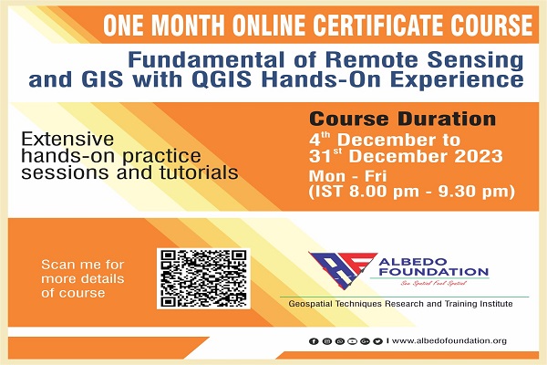
Google Earth Engine is a computing platform that allows users to run geospatial analysis on Google's infrastructure. There are several ways to interact with the platform. The Code Editor is a web-based IDE for writing and running scripts. Explorer is a lightweight web app for exploring our data catalogue and running simple analyses. The client libraries provide Python and JavaScript wrappers around our web API.
This course is specially designed for those new to the GEE platform and those not from the programming academics/background. This course will boost your geospatial data handling and analysis skills and prepare you for future job opportunities in RS and GIS industries.
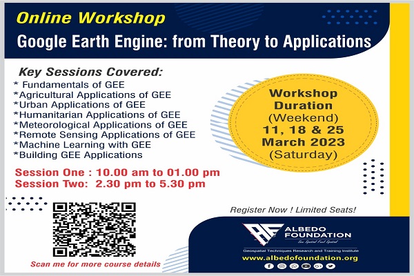
This is a three-week course (Saturday only) of 16 hours with hands-on training and assignments. The credits will be given according to attendance during the course work and performance during the hands-on and assignment submissions, along with the score in the online quiz during the entire course work. A minimum of 50% credits are required to avail of the online course e-certificate, which will strengthen your resume at various levels.
What You Will Learn in the course:
1. Fundamentals of Google Earth Engine
Google Earth Engine is a cloud-based platform for analyzing, visualizing, and storing geospatial data. It offers a range of tools for processing and analyzing massive amounts of remote sensing and other geospatial data using Google's infrastructure.
Here are some of the fundamentals of Google Earth Engine that would be covered:
Data: Google Earth Engine offers a wide range of publicly available datasets, including satellite imagery, climate data, and terrain data. Some of the key datasets include Landsat, Sentinel-2, MODIS, and DEM.
Code Editor: Google Earth Engine provides an integrated code editor that allows users to write, test, and run code for processing and analyzing geospatial data. The code editor also provides various tools for debugging, profiling, and sharing code.
JavaScript API: Google Earth Engine provides a JavaScript API that allows developers to build custom applications and visualizations using geospatial data. The API provides access to the same functionality as the code editor, allowing developers to leverage the full power of Google Earth Engine.
Image Collections: Google Earth Engine represents geospatial data as image collections, which are essentially a sequence of images over time. Image collections can be filtered, sorted, and processed using a wide range of functions.
Processing and Analysis: Google Earth Engine provides a wide range of functions for processing and analyzing geospatial data, including image manipulation, statistics, machine learning, and time series analysis. These functions can be used to perform a variety of tasks, such as land cover classification, change detection, and trend analysis.
Visualization: Google Earth Engine provides a range of tools for visualizing geospatial data, including interactive maps, time series charts, and image exports. Visualization tools can be used to explore and analyze data, and to create custom visualizations for presentations and reports.
Collaboration and Sharing: Google Earth Engine allows users to collaborate on projects and share code and data with other users. Projects and code can be shared publicly or privately, and users can collaborate in real-time using the built-in chat and collaboration features.
2. Agricultural applications of GEE
Google Earth Engine can be used for a wide range of agricultural applications, from monitoring crop health to predicting yields and analyzing land use patterns. Here are some of the key agricultural applications of Google Earth Engine that would be covered:
Crop Monitoring: Google Earth Engine can be used to monitor crop health and growth using remote sensing data, such as Landsat or Sentinel-2 imagery. Using image processing and machine learning algorithms, it is possible to identify and track changes in vegetation indices, such as NDVI, which can be used to identify areas of stress or damage in crops.
Yield Prediction: Google Earth Engine can also be used to predict crop yields by analyzing historical weather data and remote sensing imagery. By combining this data with crop models and machine learning algorithms, it is possible to create accurate predictions of future crop yields.
Land Use Mapping: Google Earth Engine can be used to create detailed maps of land use and land cover, including cropland, pasture, and forested areas. These maps can be used to identify trends in land use patterns over time and to develop strategies for sustainable land management.
Soil Moisture Monitoring: Google Earth Engine can be used to monitor soil moisture levels using data from remote sensing sensors such as Sentinel-1. This data can be used to improve irrigation practices and reduce water usage.
Drought and Flood Monitoring: Google Earth Engine can be used to monitor drought and flood conditions by analyzing remote sensing and weather data. This information can be used to help farmers make informed decisions about crop management and water use.
Precision Agriculture: Google Earth Engine can be used to create detailed maps of fields, which can be used to implement precision agriculture practices. This includes the use of variable-rate fertilization and irrigation, which can help to improve yields and reduce environmental impact.
3. Urban applications of Google Earth Engine
Google Earth Engine can also be used for a variety of urban applications, from monitoring urban growth and change to analyzing urban heat islands and air quality. Here are some of the key urban applications of Google Earth Engine that would be covered:
Urban Growth and Change: Google Earth Engine can be used to monitor and analyze urban growth and change over time using historical satellite imagery. This information can be used to understand patterns of urbanization and to plan for future development.
Land Use Mapping: Google Earth Engine can be used to create detailed maps of land use and land cover in urban areas, including parks, green spaces, and other public areas. These maps can be used to inform urban planning and management decisions.
Urban Heat Islands: Google Earth Engine can be used to analyze and map urban heat islands, which are areas where temperatures are higher in urban areas than in surrounding rural areas. This information can be used to develop strategies for reducing the impact of urban heat islands, such as planting trees and increasing green spaces.
Air Quality: Google Earth Engine can be used to analyze and map air quality in urban areas using data from sensors and satellite imagery. This information can be used to identify areas of high pollution and to develop strategies for reducing air pollution.
Disaster Response: Google Earth Engine can be used to support disaster response efforts in urban areas by providing real-time satellite imagery and other geospatial data. This information can be used to assess damage and plan for relief efforts.
Traffic Analysis: Google Earth Engine can be used to analyze traffic patterns in urban areas using data from traffic sensors and other sources. This information can be used to optimize traffic flow and reduce congestion.
4. Humanitarian applications of Google Earth Engine
Google Earth Engine can be a valuable tool for a range of humanitarian applications, from disaster response and recovery to human rights monitoring and conflict resolution. Here are some of the key humanitarian applications of Google Earth Engine that would be covered:
Disaster Response and Recovery: Google Earth Engine can be used to support disaster response efforts by providing real-time satellite imagery and other geospatial data. This information can be used to assess damage, identify areas of need, and plan for relief efforts.
Climate Change: Google Earth Engine can be used to analyze and map the impact of climate change on vulnerable populations. This information can be used to develop adaptation strategies and to advocate for policies that address climate change.
Food Security: Google Earth Engine can be used to monitor crop health and yield predictions to support food security initiatives. This information can be used to identify areas of need and to develop strategies to improve agricultural practices.
Human Rights Monitoring: Google Earth Engine can be used to monitor and document human rights abuses, including forced displacement, land grabbing, and environmental degradation. This information can be used to hold governments and corporations accountable and to support advocacy efforts.
Conflict Resolution: Google Earth Engine can be used to monitor and map conflict zones, track population movements, and support peacebuilding efforts. This information can be used to identify areas of risk and to support conflict resolution and peacebuilding efforts.
Public Health: Google Earth Engine can be used to support public health initiatives, including disease outbreak monitoring and vaccination campaigns. This information can be used to identify areas of need and to plan for health interventions.
5. Meteorological applications of GEE
Google Earth Engine can be a valuable tool for a range of meteorological applications, from weather forecasting and climate monitoring to drought assessment and flood mapping. Here are some of the key meteorological applications of Google Earth Engine that would be covered:
Weather Forecasting: Google Earth Engine can be used to generate weather forecast models using data from satellites and other sources. This information can be used to provide more accurate and timely weather forecasts.
Climate Monitoring: Google Earth Engine can be used to monitor and analyze changes in climate patterns over time using historical satellite imagery and climate data. This information can be used to identify trends and patterns in climate change and to develop strategies for adaptation and mitigation.
Drought Assessment: Google Earth Engine can be used to monitor and map drought conditions using data from satellites and other sources. This information can be used to assess the severity and extent of droughts and to develop strategies for drought management.
Flood Mapping: Google Earth Engine can be used to generate flood maps using data from satellites and other sources. This information can be used to identify areas at risk of flooding and to develop strategies for flood management.
Fire Risk Assessment: Google Earth Engine can be used to analyze and map fire risk using data from satellites and other sources. This information can be used to identify areas at risk of wildfires and to develop strategies for fire prevention and management.
Air Quality: Google Earth Engine can be used to analyze and map air quality using data from sensors and satellite imagery. This information can be used to identify areas of high pollution and to develop strategies for reducing air pollution.
6. Remote sensing applications of Google Earth Engine
Google Earth Engine is a powerful platform for remote sensing applications, which involve the analysis and interpretation of data collected from satellites and other airborne sensors. Here are some of the key remote sensing applications of Google Earth Engine that would be covered are:
Land Cover and Land Use Mapping: Google Earth Engine can be used to create land cover and land use maps by analyzing satellite imagery. This information can be used for environmental monitoring, urban planning, and agricultural management.
Forest Monitoring: Google Earth Engine can be used to monitor and analyze changes in forest cover and biomass using satellite imagery. This information can be used for forest management, conservation, and carbon accounting.
Water Resources Management: Google Earth Engine can be used to monitor and map water resources, including water availability, quality, and usage. This information can be used for water management, drought assessment, and flood forecasting.
Disaster Response: Google Earth Engine can be used to provide real-time information and imagery in the event of a disaster, such as a hurricane, earthquake, or wildfire. This information can be used to assess damage, locate victims, and plan for relief efforts.
Biodiversity Conservation: Google Earth Engine can be used to map and monitor biodiversity by analyzing satellite imagery and other data. This information can be used for conservation planning and monitoring of endangered species.
Climate Change: Google Earth Engine can be used to monitor and analyze changes in the Earth's climate using satellite data. This information can be used for climate modeling, carbon accounting, and the development of strategies for adaptation and mitigation.
7. Machine learning with Google Earth Engine
Google Earth Engine (GEE) is a cloud-based platform for analyzing and processing geospatial data. It provides a powerful set of tools for machine learning (ML) applications with remote sensing data. Here are some steps for using machine learning with Google Earth Engine:
Collect and preprocess data: The first step is to collect the necessary data for your ML model. You can access a large collection of remote sensing data from GEE, including Landsat, Sentinel-2, MODIS, and others. Once you have the data, preprocess it to remove noise, fill gaps, and create features that can be used for training.
Create a training dataset: Next, you need to create a training dataset for your ML model. This involves selecting areas that represent the different land cover types you want to classify, and extracting the features that will be used for training.
Train the model: Once you have your training dataset, you can use a variety of machine learning algorithms available in GEE, such as Random Forest, Support Vector Machines (SVM), and Neural Networks. Train the model on the training dataset, and tune the hyperparameters to improve the performance.
Evaluate the model: Once the model is trained, evaluate its performance using metrics such as accuracy, precision, recall, and F1 score. You can use the validation dataset to assess the model's accuracy.
Apply the model: After evaluating the model, you can apply it to classify the land cover over a larger area or to monitor land cover changes over time. GEE provides tools to export the results and visualize them on a map.
8. Building Google Earth Engine applications
Building Google Earth Engine applications involves developing and deploying custom code using the GEE JavaScript API. Here are the general steps for building GEE applications that would be covered:
Understand the data and the problem: Before starting any GEE application, it is important to have a clear understanding of the geospatial data and the problem you are trying to solve. This includes identifying the relevant data sources, the spatial and temporal scales, and the target application (e.g., land cover classification, vegetation monitoring, etc.).
Write and test code in the Code Editor: GEE provides a Code Editor interface where you can write, debug, and test your code. The Code Editor allows you to create custom scripts in the GEE JavaScript API, which can be used to access and process geospatial data. You can use the Code Editor to load datasets, visualize data, create functions, and run analyses.
Develop the application: Once you have a working prototype in the Code Editor, you can start building your application. This involves writing and organizing your code, creating a user interface, and deploying the application. GEE applications can be built using a range of frameworks, such as Angular, React, or Vue.js. You can also use GEE's built-in user interface components, such as the Map widget and the Chart widget, to create custom dashboards and visualizations.
Deploy the application: Once your application is developed, you can deploy it to a hosting platform. GEE provides a built-in hosting platform called Earth Engine Apps, which allows you to deploy your application as a web app. Earth Engine Apps provides a secure and scalable environment for running GEE applications, and allows users to interact with your application through a web browser.
Monitor and maintain the application: After deploying your application, you should monitor its performance and user feedback. You may need to make updates or bug fixes as new issues arise. GEE provides a range of debugging tools, logging utilities, and error handling mechanisms to help you maintain and improve your application over time.
Know our course instructor
Dr. Manmeet Singh
He is working as Scientist D at Indian Institute of Tropical Meteorology, Pune. He has pursued PhD from Indian Institute of Technology Bombay in Climate Science. His area of expertise is climate modelling and Machine Learning/Deep learning.
Prerequisite
For whom
Course Duration
11, 18, and 25 March 2023 (Saturday)
Session One: 10.00 am to 01.00 pm
Session Two: 2.30 pm to 5.30 pm
Limited Seats... Register Now!
Albedo Foundation was a platform I knew I needed for the basics of RS and GIS but didn't know where to begin or what questions to ask. This course made a foundation and did everything-with almost no time or effort for me. I also got the best guidance from a tutor, which saved me countless hours of self-teaching. I've performed and explored the possibilities of 'Google Earth Engine.
Ashutosh Umale
Arvind Gauns
Developed by Collabx