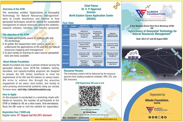
The short-term workshop (STW) entitled “Applications of Geospatial Technology for Natural Resources Management” aims to create awareness and interest in how geospatial techniques would be utilized by one for sustainable management of natural resources among the students, research scholars, faculties, and industry personnel. As the program is conducted in a workshop mode with hands-on sessions, the number of participants in the STW is limited to 40 on a first-come, first-serve basis.
The participants will get the recorded sessions of the workshop on our Albedo Foundation android app only for one month’s validity.
The Objectives of STW
Chief Patron
Dr. S. P. Aggarwal, Director, North Eastern Space Application Center (NESAC)

Resource Persons
Dr. Bhaskar R. Nikam, Scientist/Engineer- SF, Water Resources Department, IIRS

Dr. Vaibhav Garg, Scientist/Engineer- SF, Water Resources Department, IIRS
Ms. Asfa Siddiqui, Scientist/Engineer - SE, Urban, and Regional Studies Department, IIRS

Mr. Saikat Maiti

Dr. Unmesh Khati, Assistant Professor, Department of Astronomy, Astrophysics and Space Engineering, IIT Indore

Dr. Saurabh Vijay, Assistant Professor, Civil Engineering Department, IIT Roorkee

Dr. Ajanta Goswami, Associate professor, Earth Sciences Department, IIT Roorkee

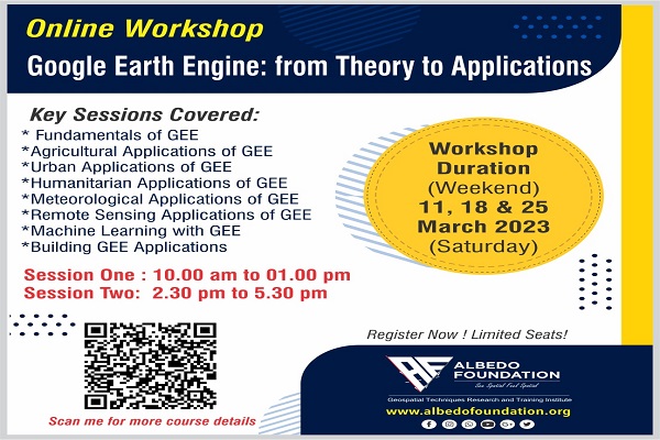
STW Time Table (IST)
10:30 am - 11.30 am - Lecture (Webinar) 01
12:00 pm - 01:00 pm - Lecture (Webinar) 02
02:00 pm - 5:00 pm - Hands-on Training
|
DATE |
10.00 am - 10.30 am |
10.30 am - 11.30 am |
12.00 pm - 01.00 pm |
1.00 pm -2.00 pm |
2.00 pm - 5.00 pm |
|---|---|---|---|---|---|
|
20/08/2022 |
Workshop Inauguration |
Application of Geospatial Technology for Watershed Management |
Flood Mapping, Monitoring, and Damage Assessment using Remote Sensing |
LUNCH BREAK |
Watershed Delineation using DEM and GIS tools |
|
21/08/2022 |
|
Remote Sensing-based Analysis of Urban Heating and Urban Air Pollution |
OpenStreetMap (OSM) for Urban Planning |
Assessment of Urban Heat Islands using RS and GIS |
|
|
27/08/2022 |
Introduction to SAR Polarimetry and its Applications |
Introduction to SAR Interferometry and Its Applications |
Polarimetric Analysis of SAR Data using PoLSAR pro |
||
|
28/08/2022 |
Applications of Geospatial Technology in Geological Hazards |
Google Earth Engine (GEE) for Natural Resource Management |
Geospatial Analysis using Python |
Early Bird Registration
Register on or before 18th August 2022 and get an exclusive offer of a 30% discount. Apply coupon code: AFOW30
Developed by Collabx